Wednesday, June 23, 2010

Day1: Colorado National Monument

The first day was a a short day to get us warmed up I guess. I was not an especially easy day because there was about a 2,000 foot elevation gain with lots of ups and downs as well. The map, elevation profile, and  a route description are below.


38 Miles and approximately 2500 feet of Climbing.  I really like this as a first day ride.  It’s just shy of 40 miles and gives you a good amount of climbing and ALL day to enjoy the monument.  No need to get up at sunrise.  You don’t need to take down your tent and set it up someplace else (unless you neighbor snores too loudly).  Even by sleeping in, you can start and end the ride before the heat of the day.  Neat concept and a great way to start a tour. The Monument is a beautiful ride with stunning vistas, switchbacks, tunnels, and scenery.  The climbing can get steep in a few areas, approaching 9% on the southern end, but the extreme grades are fairly short.  There are plenty of places to pull over, take a breather, and enjoy the views.  Please note, there are very significant drop-offs here, so if you don’t like heights, the roads may cause your heart to flutter a bit.  


The day started out very nice. The road was flat for a bit, and then we begin to climb into the monument.
The scenery was just beautiful as we got on top of the monument. I highly recommend seeing if you are close.


We look pretty good at this point. You can see that it was beginning to cloud up and threatening to storm. We didn't stop for very long and headed out of the monument on the long, fast downhill. As we got to flat road back into GJ, we heard some thunder and it sprinkled on us a bit. We didn't think too much about it. We finished and put our bikes away and headed for some liquid and food. When we came back, we noticed lines of people washing their bikes. We couldn't figure out what they were doing and thought they were just some kind of neat freaks. Then we begin to look carefully and they and their bikes were filthy. They had gotten caught in the rain and the hail in the Monument. I'm so glad we didn't dally on top or we would have gotten it as well.


Day one ended with food, and chilling in the tent.

Getting to Grand Junction

We had virtually no Internet connection during the ride so we posted almost nothing to the BLOG. Over the next few days, I plan to write one post per day of the ride. So, if you are interested, stay tuned.

The day before we going to leave, I put new tires on my bike. I had told Luke about the pothole that I hit in a ride earlier. He was spinning my wheel and noticed how out of round it was. As we looked at the rim where the flat spot was, we noticed a crack in the rim. Upon closer inspection, we found a couple of others on the front and the rear rims.


We decided that it as not safe to go downhill at 45 mph on such a wheel. So, we made a quick trip to Old Town and bought new wheels. I told Luke he saved my life and cost me $750.00. But, I now have really nice new wheels that are better than what I had.

We packed up and left Saturday AM. Thanks so much to Bob W. for giving up his Saturday to drive us to Grand Junction. That helped our logistics a bunch. As we climbed out of Denver towards the Eisenhower Tunnel, it begin to rain, and then to snow. I'll have to admit that I was getting a bit nervous as I watched the snow fall at altitudes well below where we would be riding in a couple of days.


We arrived in Grand Junction, unloaded our bikes and stuff, said goodbye to Bob, and begin to figure out how this worked. Every city had what we called Tent City. A field full of tents. Here is the one from GJ.

It was pretty wet on the infield; hence the area in the middle where there are no tents. We walked around, went to REI to get a pillow for Luke, found some supper, and played cards until bed time. I was beginning to get that feeling before a big event. A combination of nervousness and let's get on with it.

Sunday, June 13, 2010

Day one complete!

We rode a 45 mile loop out of grand junction up and over the Colorado national monument. Rim rock drive is one of the most scenic places i've ever ridden. The climb was quite steep but never got too bad. We left early enough and were riding fast enough that we beat the thunderstorm that pounded the monument. Now, we are just relaxing and preparing for tomorrows brutal climbing.

a few pictures from day one

Tuesday, June 8, 2010

Packed and ready to go

Boxed up the bike and packed everything tonight. I thought I packed light and I still have a ton of crap. Can't wait to be in Colorado tomorrow night. Bike-in-a-box:

Day 4 Preview: Ouray -> Durango

[this day is really why I started the preview posts. I was looking at pictures of the passes we were going to climb and decided to do that for each day. Of course, now there are only 4 days left until we start riding]

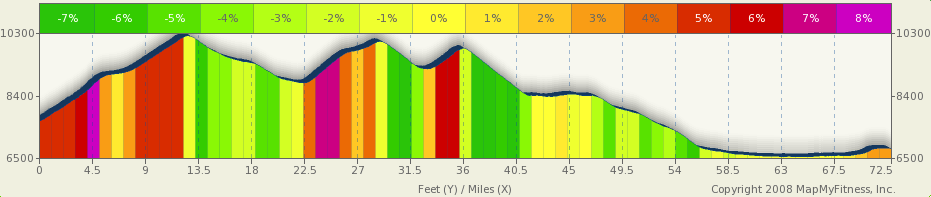
After an evening in Ouray we'll set out bright and early for Durango. We'll be riding 72.5 miles with about 6,500 feet of climbing up Red Mountain Pass, Molas Divide and Coal Bank Pass. Between Ouray and Silverton we'll be riding what is known as the Million Dollar Highway. This will be a hard day, but probably not as hard as Grand Mesa. It will be an incredibly scenic day as you can see by the photos below. I hope we get beautiful weather for stage 4 because the climb up Red Mountain Pass and the descent into Silverton are supposed to be some of the most scenic in Colorado. Here is a view we'll get before going up and over Red Mountain Pass:

CC photo from flickr user M Bergman

And here is a view from Red Mountain Pass (you can see the highway on the left):

CC photo from flickr user Eleaf

The top of Red Mountain Pass is 11,018ft and then we scream down into Silverton, an old silver mining camp. From here, we could take the narrow gauge rail into Durango, but then we'd miss all the fun on the next two passes. Here's a picture of Molas lake before we climb up and over Molas Divide:

CC photo from flickr user StevenM_61

Next up is Coal Bank Pass and then it's a downhill all the way into Durango. I couldn't find a good picture of Coal Bank but here's a picture of Electra Lake, which we'll ride past on the way into Durango:

CC photo from flickr user ElCapitan


The final aid station on stage 4 is Honeyville at mile 61. Mmm. Honey sticks! The elevation profile is below and check out the stage profile on MapMyRide.


This will probably be one of the most scenic rides I've ever done. Certainly the most scenic road ride I've done. And 8 days from now I'll let you know how it went!

Saturday, June 5, 2010

1 Week to go

We start one week from tomorrow. Another way to think about it is we finish 2 weeks from today. I'm actually ready to do it.

In Vail, I did three pretty intense days of climbing. Day 1 was Vail to Vail Pass. It was cool and cloudy. In fact I got pretty cold on the way down. Here is a picture from the top.


 Day 2 I intended to ride to Tennessee Pass, but got confused with directions and rode 15 miles or so in the valley.  I did get over Battle Mountain and part of the way up Tennessee Pass. Here is a picture from the top of Battle Mountain.


Day 3 I did make it to the top of Tennessee pass. From Minturn, that is about 2,700 feet of climbing. It is in two steep sections. Battle Mountain is about 4 miles and 900 feet or so. Then there is a short downhill and a fairly long ride through a big valley. Here is a picture in the valley. You can see that it was a nice day than the previous 2.


The final ascent to Tennessee Pass is about 5 miles and 1,000 feet or so.


So, I feel a bit better about getting over the passes.

Today, I did 100k averaging 27 kph. That is pretty fast for me riding solo.

Now, I need to let some saddle sores heal a bit. I'd post a picture, but this is family BLOG. :)

Friday, June 4, 2010

Day 3 Preview: Delta --> Ouray

The third day of Ride the Rockies will be a lot easier than the previous day over Grand Mesa. We'll start in Delta, CO and ride 66.6 miles up into Ouray, CO. The route profile posted by the Tour Director says we'll start out on some country roads that will be rough. I'm just looking forward to an easy day of riding after two hard days. The route is mostly uphill but we will only climb 3,235 feet on the way to Ouray (click for a larger version):


The first 30 miles will be on small country roads and then we'll pull into Montrose. From there it's a straight shot up into Ouray, CO. As we leave Montrose we'll be treated to views of the San Juan mountains and Uncompahgre National Forest. It will likely be hot day so I'm sure a stop at on eof the ice cream shops in Montrose will be a nice break. As we approach Ouray the valley will narrow and the road will steepen. After going through the narrowest part of the valley, we'll pull into Ouray:


cc photo by flickr user maryn0503

I'm looking forward to spending time in the hot springs in Ouray and resting my legs for the next day's ride to Durango!

Update: I forgot to include the link to the MapMyRide profile for the stage. The last six miles on the google earth 3d tour looks pretty awesome. Going to be a beautiful ride.