We rode a 45 mile loop out of grand junction up and over the Colorado national monument. Rim rock drive is one of the most scenic places i've ever ridden. The climb was quite steep but never got too bad. We left early enough and were riding fast enough that we beat the thunderstorm that pounded the monument. Now, we are just relaxing and preparing for tomorrows brutal climbing.
a few pictures from day one
Sunday, June 13, 2010
Tuesday, June 8, 2010
Packed and ready to go
Boxed up the bike and packed everything tonight. I thought I packed light and I still have a ton of crap. Can't wait to be in Colorado tomorrow night. Bike-in-a-box:


Day 4 Preview: Ouray -> Durango
[this day is really why I started the preview posts. I was looking at pictures of the passes we were going to climb and decided to do that for each day. Of course, now there are only 4 days left until we start riding]
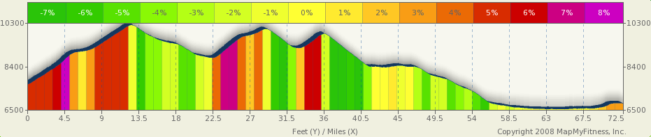
After an evening in Ouray we'll set out bright and early for Durango. We'll be riding 72.5 miles with about 6,500 feet of climbing up Red Mountain Pass, Molas Divide and Coal Bank Pass. Between Ouray and Silverton we'll be riding what is known as the Million Dollar Highway. This will be a hard day, but probably not as hard as Grand Mesa. It will be an incredibly scenic day as you can see by the photos below. I hope we get beautiful weather for stage 4 because the climb up Red Mountain Pass and the descent into Silverton are supposed to be some of the most scenic in Colorado. Here is a view we'll get before going up and over Red Mountain Pass:

And here is a view from Red Mountain Pass (you can see the highway on the left):

The top of Red Mountain Pass is 11,018ft and then we scream down into Silverton, an old silver mining camp. From here, we could take the narrow gauge rail into Durango, but then we'd miss all the fun on the next two passes. Here's a picture of Molas lake before we climb up and over Molas Divide:

Next up is Coal Bank Pass and then it's a downhill all the way into Durango. I couldn't find a good picture of Coal Bank but here's a picture of Electra Lake, which we'll ride past on the way into Durango:

The final aid station on stage 4 is Honeyville at mile 61. Mmm. Honey sticks! The elevation profile is below and check out the stage profile on MapMyRide.

After an evening in Ouray we'll set out bright and early for Durango. We'll be riding 72.5 miles with about 6,500 feet of climbing up Red Mountain Pass, Molas Divide and Coal Bank Pass. Between Ouray and Silverton we'll be riding what is known as the Million Dollar Highway. This will be a hard day, but probably not as hard as Grand Mesa. It will be an incredibly scenic day as you can see by the photos below. I hope we get beautiful weather for stage 4 because the climb up Red Mountain Pass and the descent into Silverton are supposed to be some of the most scenic in Colorado. Here is a view we'll get before going up and over Red Mountain Pass:

CC photo from flickr user M Bergman
And here is a view from Red Mountain Pass (you can see the highway on the left):

CC photo from flickr user Eleaf
The top of Red Mountain Pass is 11,018ft and then we scream down into Silverton, an old silver mining camp. From here, we could take the narrow gauge rail into Durango, but then we'd miss all the fun on the next two passes. Here's a picture of Molas lake before we climb up and over Molas Divide:

CC photo from flickr user StevenM_61
Next up is Coal Bank Pass and then it's a downhill all the way into Durango. I couldn't find a good picture of Coal Bank but here's a picture of Electra Lake, which we'll ride past on the way into Durango:

CC photo from flickr user ElCapitan
The final aid station on stage 4 is Honeyville at mile 61. Mmm. Honey sticks! The elevation profile is below and check out the stage profile on MapMyRide.
This will probably be one of the most scenic rides I've ever done. Certainly the most scenic road ride I've done. And 8 days from now I'll let you know how it went!
Saturday, June 5, 2010
1 Week to go
We start one week from tomorrow. Another way to think about it is we finish 2 weeks from today. I'm actually ready to do it.
In Vail, I did three pretty intense days of climbing. Day 1 was Vail to Vail Pass. It was cool and cloudy. In fact I got pretty cold on the way down. Here is a picture from the top.

Day 2 I intended to ride to Tennessee Pass, but got confused with directions and rode 15 miles or so in the valley. I did get over Battle Mountain and part of the way up Tennessee Pass. Here is a picture from the top of Battle Mountain.

Day 3 I did make it to the top of Tennessee pass. From Minturn, that is about 2,700 feet of climbing. It is in two steep sections. Battle Mountain is about 4 miles and 900 feet or so. Then there is a short downhill and a fairly long ride through a big valley. Here is a picture in the valley. You can see that it was a nice day than the previous 2.

The final ascent to Tennessee Pass is about 5 miles and 1,000 feet or so.

So, I feel a bit better about getting over the passes.
Today, I did 100k averaging 27 kph. That is pretty fast for me riding solo.
Now, I need to let some saddle sores heal a bit. I'd post a picture, but this is family BLOG. :)
Friday, June 4, 2010
Day 3 Preview: Delta --> Ouray
The third day of Ride the Rockies will be a lot easier than the previous day over Grand Mesa. We'll start in Delta, CO and ride 66.6 miles up into Ouray, CO. The route profile posted by the Tour Director says we'll start out on some country roads that will be rough. I'm just looking forward to an easy day of riding after two hard days. The route is mostly uphill but we will only climb 3,235 feet on the way to Ouray (click for a larger version):

The first 30 miles will be on small country roads and then we'll pull into Montrose. From there it's a straight shot up into Ouray, CO. As we leave Montrose we'll be treated to views of the San Juan mountains and Uncompahgre National Forest. It will likely be hot day so I'm sure a stop at on eof the ice cream shops in Montrose will be a nice break. As we approach Ouray the valley will narrow and the road will steepen. After going through the narrowest part of the valley, we'll pull into Ouray:

I'm looking forward to spending time in the hot springs in Ouray and resting my legs for the next day's ride to Durango!
Update: I forgot to include the link to the MapMyRide profile for the stage. The last six miles on the google earth 3d tour looks pretty awesome. Going to be a beautiful ride.
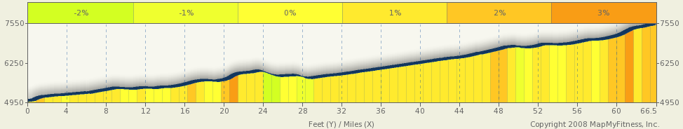
The first 30 miles will be on small country roads and then we'll pull into Montrose. From there it's a straight shot up into Ouray, CO. As we leave Montrose we'll be treated to views of the San Juan mountains and Uncompahgre National Forest. It will likely be hot day so I'm sure a stop at on eof the ice cream shops in Montrose will be a nice break. As we approach Ouray the valley will narrow and the road will steepen. After going through the narrowest part of the valley, we'll pull into Ouray:

cc photo by flickr user maryn0503
I'm looking forward to spending time in the hot springs in Ouray and resting my legs for the next day's ride to Durango!
Update: I forgot to include the link to the MapMyRide profile for the stage. The last six miles on the google earth 3d tour looks pretty awesome. Going to be a beautiful ride.
Break in training for an adventure race
This past weekend I (Luke) took a break from raining for Ride the Rockies and competed in an adventure race in West Virginia. The Wild and Wonderful 24HR adventure race is put on by Odyssey Adventure Racing and is one of the funnest races I've done. I was competing on a 4-person team for TeamHalfwayThere.com. We started off with some whitewater rafting down the New River toward the New Ricer Gorge Bridge. After that it was 23.5 hours of mountain biking and trekking through the West Virginia mountains. The course was weighted heavily toward biking so I think it was a great training for Ride The Rockies. I even spent much of the racing towing a teammate up the hills when the terrain permitted it.
The hilghlight for me was a mountain bike time trial over thirteen miles of sinlge-track trails and fire roads. THe kicker was we had to do it at night after having raced for 15 hours. Riding technical trails at night is an aboslute blast and forces you to stay alert even when you are dead tired.
We had a wonderful race and ended up finishing 3rd in the co-ed division and 5th overall. The 3rd place finish gave us enough points to move up to 11th place in the CheckPoint Tracker standings and pretty much guarantees an invite to the championship race in Moab in October.
Wednesday, June 2, 2010
Vail Pass
Last week from Tuesday to Monday (7 days) I (Chuck) rode 491k (304mi). I felt good about the total distance. I did two 100k+ rides back to back. The first one went really well. I rode some hills, and rode pretty fast. I was feeling pretty encouraged after that ride. The next day I had planned on riding up to Woodland Park and then up the Rampart Range Road to get some long climbing in. This was Saturday morning, and I thought I would beat the wind and that the Memorial Day traffic would be over. Well, the wind was awful, and the traffic was NOT light. I can deal with cars, but pickups pulling big RVs is another thing. Plus, the wind was in my face, and gusting enough to move me around on the road. I got on highway 24 above Manitou Springs, and decided I wouldn't take my life in my hands so I turned around at the first opportunity.
So, as an alternate, I decide to look for all the hills I could find on the west side of town. I first headed up 26th street to the south. That is actually a long, steady climb which was, of course, into the wind. I got to where it intersected Gold Camp Road and headed up that. A couple of hundred yard further up, I got hit by a gust of wind so strong that I almost lost control. Once again, discretion being the better part of valor, I turned around and went downhill.
My next challenge was to ride up Cheyenne Canyon. This is a beautiful drive, and a steep climb. once again, the wind was either cross or head and it was a tough haul. Close to the top, I got hit by a cross wind so strong that I had a hard time riding a straight line, so downhill I went. I pondered doing that again, but decided that was not smart.
I rode by a local deceased artists house and took this picture. The artist was a retired mining engineer and loved to make wonderful moving sculptures. His neighbors have not been all that excited about it, but I think they are both beautiful and an engineering feat.

Next on my agenda was the ride up to the zoo. This is also a long steady climb from the Broadmoor through the ritzy part of town. Yes, it was into the wind and by now, it was getting pretty hot. But, I made it to the entrance. On the way down I hit a pothole doing about 30. I thought sure both tires would go, but they seem fine. I need to true my front wheel a bit, but I've ridden over 100 miles since then with not issues.
By now, I was pretty fried (both legs and from the heat). I headed back to the East side of town and rode a loop near my house until I got to 110k and quit. Riding a loop in a strong wind works for me since you don't have to fight the wind for many miles. I was spent--bonked a little, and out of fluid even thought I drank about 4 quarts while on the bike.
Finally, to Vail Pass. I had posted on FaceBook my intentions to go to the mountains while my wife is in Ohio so I could ride at higher altitude and try some long climbs (passes). Jeanne, a good friend, saw that and volunteered the last few days of a time share that they were able to use. So, early on Wednesday, I took off for Vail. After I arrived, I headed out towards Vail Pass. Vail is about 8,100 feet; the top of the pass is about 10,600 feet. They have take the old highway for much of the way on the west side of the pass and turned into a bikes only. It was wonderful to ride up. A bit more than halfway, it turned into a well paved bike path. I made it all the way to the top without too much difficulty. Here is a picture from the top.

As you can tell, it was cloudy, and pretty chilly at the top. I got very chilled on the ride down where I averaged well over 25mph.
It was a big confidence builder for me to be able to ride a long pass (the signs on the road on the way down said it was a 7% grade) at high altitude. This was the first time I had ridden over 9,000 feet in my life so I really didn't know how I would react.
Either tomorrow or Friday, I'm planning on attempting Tennessee Pass. We shall see how that goes.
Subscribe to:
Posts (Atom)
